Pico da Tijuca Hike Guide: Trail, Summit Stairs & Access
Written and reviewed by Lotte — Rio local, founder & editor of PlanRio · How we research · First published · Last reviewed
Quick answer
Pico da Tijuca is the 1,022 m high point of Tijuca National Park. Enter Setor Floresta at Praça Afonso Viseu; the park’s Pico page sets a 14:00 latest trail start, while general pedestrian sector access begins at 06:00. Check current rules, weather and transport, and treat the exposed summit staircase as optional.
Links may earn us a commission at no extra cost to you. This supports PlanRio.
At a glance
Where
Setor Floresta, Tijuca National Park; the access point is Praça Afonso Viseu, Alto da Boa Vista.
Summit
1,022 m above sea level; the park identifies Pico da Tijuca as its highest point.
Trail start
The park’s Pico page says to begin by 14:00. Check that page and any closure notice on the day.
Park access
Current general rules allow pedestrian entry to Setor Floresta from 06:00; the route page has its own earlier turnaround planning advice.
Public transport
The park lists 301, 302 and 345; a current stop listing shows 301, 302, 645 and 448. Check live service to Praça Afonso Viseu.
Route choice
The summit hike is distinct from the 19 km Circuito dos Picos, which the park recommends walking over two or three days.
What the Pico da Tijuca hike is like
Pico da Tijuca is a rainforest summit in Setor Floresta, the largest visitor sector of Tijuca National Park. The park’s current location page identifies it as the highest point inside the national park at 1,022 metres. It is a trail to a summit, rather than a viewpoint beside a road: you travel into the forest, walk an uphill route and finish on a small exposed summit area.
The reward is a wide view over Rio’s green massif and urban districts when cloud allows. Because the mountain sits within the forest, the experience is not an uninterrupted climb with a panoramic view at every turn. Expect much of the approach to feel enclosed by vegetation, with the mountain scenery opening up near the top. On a humid or overcast day, the forest can still be a satisfying destination even if the city panorama is hidden.
This page focuses on the normal summit objective and the decisions that shape a safe outing: the correct entrance, the route-specific start cutoff, whether the final steps suit you, and how to get back after the hike. For a broader comparison of short and long walks around the city, use our guide to Rio’s best hikes.
Do not confuse the summit hike with the Circuito dos Picos
The name Pico da Tijuca also appears in longer route descriptions, which can make online maps and trip reports difficult to compare. The official Circuito dos Picos is a separate, 19 kilometre route passing ten named peaks in Setor Floresta. The park recommends allowing two or three days for that circuit and says its sections can be walked separately. Those figures describe the circuit, not automatically the ordinary outing to Pico da Tijuca.
A map trace that connects Pico da Tijuca with Bico do Papagaio, Tijuca Mirim or other summits may represent a longer itinerary. Before copying its distance, elevation gain or completion time, check exactly where it begins, which peaks it includes, whether it is one-way or circular, and whether every connecting trail is currently open. A route title containing the summit name does not prove it is the direct summit approach.
For a first visit whose goal is this summit alone, choose a route description that explicitly says Pico da Tijuca and Praça Afonso Viseu or the relevant trailhead. If your real goal is the full Circuito dos Picos, treat that as a multi-day plan: study the official map, confirm overnight and access rules with park management, and do not assume that a day-hike guide covers the full circuit.
Check access hours and the summit start cutoff separately
The park’s general visitor rules say pedestrians and cyclists may enter Setor Floresta from 06:00, with access ending at 17:00; people already inside may remain until 18:00. The Pico da Tijuca location page separately says the site is open daily from 08:00 to 17:00 and that visitors may only start the trail until 14:00 so they have time to return before closing. These are different kinds of guidance, not interchangeable times.
For planning the summit, follow the more specific trail page’s 14:00 start cutoff, then verify that it still applies on your visit date. The park says severe weather can change operating hours. A road closure, maintenance notice, fire risk, storm or temporary visitor restriction can overrule a normal schedule, and a general opening time does not guarantee that every path is available.
Do not treat 14:00 as a recommended arrival time. It is the latest start published on the park’s Pico page, not a promise that a late afternoon climb is comfortable or wise. Give yourself daylight, pauses, navigation checks and time to descend. If your transport plan only gets you to the gate close to that cutoff, choose another day rather than trying to make up time on a mountain.
Find the right entrance before you leave your hotel
The official Pico page places the Setor Floresta entrance at Praça Afonso Viseu in Alto da Boa Vista. It describes two road approaches: Estrada das Furnas from Barra da Tijuca and Itanhangá, or Avenida Edson Passos from Tijuca. Enter the square or park entrance into your navigation app, rather than searching only for Tijuca National Park. The park covers several sectors and an incorrect pin can send you to a completely different part of the massif.
Praça Afonso Viseu is the start of your access plan, not a guarantee that a car can take you to the trail itself. From the entrance you still need to follow the visitor route to the start of the hike. Ask a current park employee where the Pico da Tijuca route begins, especially if signage or a closure changes the usual line. Do not substitute a map pin to a summit, waterfall or Circuito dos Picos junction for the public entrance.
The Alto da Boa Vista approach takes you away from the familiar beach and metro corridor. Add the uphill journey, the wait for a return vehicle and the walk back out to your day plan. Save the park entrance and a pickup point offline before leaving an area with reliable mobile data. The park warns that mobile signal can be weak, so a route that depends on opening a live map at every junction is not a robust plan.
The shape of the walk, from forest approach to summit
Think of the outing in three parts: reach the correct sector and trail start, climb through the forest while keeping to the marked route, then decide at the upper section whether the summit steps still feel appropriate. This mental model is more useful than relying on one precise duration copied from a visitor post. Pace, heat, rain, group size, closures and transport all change how long the day takes.
The forest portion can feel cooler than the city street, but it is not air-conditioned. Humidity and uphill effort can raise your body temperature quickly, and shade does not remove the need for drinking water or breaks. Take short pauses before you feel exhausted. Keep enough energy and water for the descent, when tired legs and wet roots can make a familiar path more demanding.
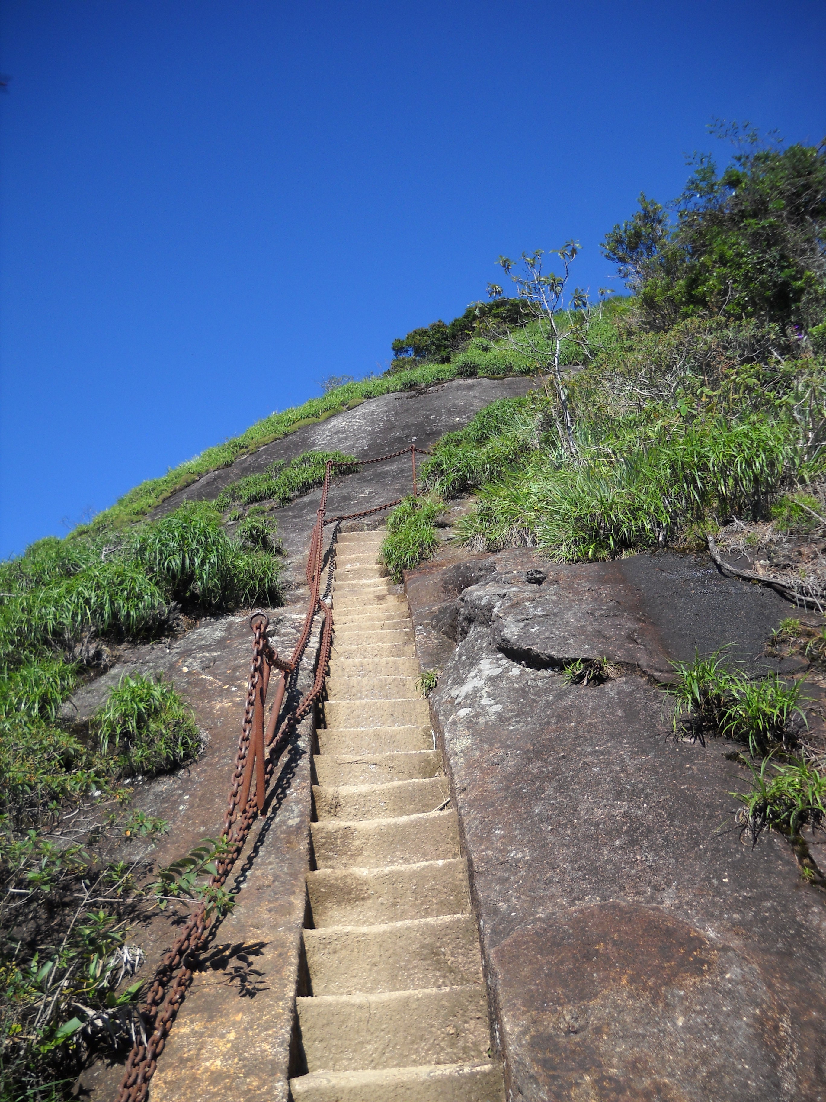
Near the summit, the character changes: the documented stone staircase and chain handrails are much more exposed than the shaded approach. This last section is a useful decision point. If the steps are wet, the chains are crowded, you feel unsteady or a storm is building, you can stop below the top and turn back. Reaching the highest rock is optional; returning safely is part of completing the hike.
The final stairs: decide before you commit
The summit approach is the part to research if you dislike heights or have limited balance. A photograph of the actual staircase is shown above. It has stone steps and fixed metal chains, but that does not turn it into an easy staircase in a city park: the stairs sit on a rocky, exposed slope and the chain is something to hold while moving carefully, not a reason to rush or pull another hiker along.
At a bottleneck, let people move one at a time and wait for space rather than stepping around someone on the exposed side. Keep both hands available when you need them. Do not stop halfway to take a phone photo, and do not climb beyond the built route to make a summit image. If the surface is wet, ask the person responsible for your group or park staff whether conditions make the section unsuitable that day.
People who are comfortable with steep steps at ground level can still discover that exposure feels different above a drop. There is no shame in deciding that the summit is not for you. Tell your companions before the ascent that you may wait at a safe point, and agree how the group will regroup without splitting into untracked side paths. If you know that chains, narrow steps or heights would make you freeze, choose a different viewpoint hike.
How difficult is Pico da Tijuca?
Difficulty has two parts here. The forest approach asks for sustained uphill walking on an uneven route; the top asks for careful movement on a steeper built section. A GetYourGuide listing for a specific guided Pico da Tijuca trip describes the hike as medium difficulty, but that is the operator’s assessment of its itinerary and group, not an official park grade or a promise that every visitor will find it moderate.
You do not need to be an endurance athlete to consider the mountain, but you should be able to walk uphill for a substantial part of the day, carry water and continue after a pause. A person who only measures fitness by distance on flat pavement may underestimate heat, humidity and footing. Try a shorter local trail first if you have not hiked on uneven ground, and be honest about knee, ankle, balance, heart or respiratory concerns.
Mobility access is limited. This is a forest trail with an exposed summit finish, not an accessible paved viewpoint. The bookable guided hike says it is not suitable for people with mobility impairments. If you use a mobility aid, need step-free access, or would require hands-on assistance over obstacles, do not book on the assumption that a guide can make the trail accessible. Contact the park or provider to discuss a realistic alternative.
Should you go with a guide?
A guide can make a remote trailhead and a complicated park day easier to manage, particularly if you are unfamiliar with Rio, speak neither Portuguese nor Spanish, have limited time, or want someone else to handle the order of stops and pickup. A guide also helps the group stay together and adapt its pace. A guided outing does not remove the need to follow park closures, carry water or decide whether the top is suitable for you.
Self-guided visitors should use current park information and mapping, know the access point, understand the trail’s start cutoff, and have enough experience to manage a forest route where mobile coverage can be weak. Go with a companion where possible. Tell someone your plan and expected return, keep the whole group on the same route, and turn back if the published route or conditions no longer match what you prepared for.
If you want help with logistics, the optional guided listing linked on this page specifically includes a hike to Pico da Tijuca, not just a general Tijuca Forest drive. Its current description names a guide, transport and hotel pickup, plus additional stops elsewhere in the park. Check the pickup zone, language, group format, included services and the actual date’s itinerary before booking; the provider may change timing or stops for weather and access.
Getting there by bus, car or app ride
The park’s Pico page lists bus lines 301, 302 and 345 for the entrance at Praça Afonso Viseu. A stop listing updated in August 2026 shows 301, 302, 645 and 448, with the latter stopping a short walk away. The sources agree on 301 and 302 but differ on other lines, so treat the park page as a useful lead rather than a live timetable. Check the trip planner on the morning of your walk and confirm the stop is actually near your chosen entrance.
If using an app ride or taxi, enter Praça Afonso Viseu rather than the summit. Agree with your group how you will request the ride out and whether mobile data is available at that point. Do not assume that a driver will wait, that a car can drive into the sector at every hour, or that you will find a ride immediately after descending. Prearrange a pickup only when the driver and meeting location are genuinely confirmed.
Drivers approaching from Tijuca can use Avenida Edson Passos; those from the Barra or Itanhangá side can approach via Estrada das Furnas, according to the park. Check the road and gate rules before setting out, especially on weekends, when nearby park roads can have their own access restrictions. The final route depends on the day’s road conditions, so avoid a tight restaurant, museum or airport booking after the hike.
Weather, cloud and rain change the experience
Rio’s weather can feel different at the forest entrance and on a high summit. Cloud may close around the peak even when the city below is bright; the opposite can also happen, with an attractive forecast at breakfast becoming a damp, low-visibility afternoon. The view is never guaranteed. If your main reason for going is a clear panorama, leave flexibility in your schedule and check a mountain-level forecast near the visit rather than trusting a general city symbol.
Rain affects more than visibility. Wet roots and rock can reduce grip, runoff can make a path unpleasant, and a slippery staircase is a poor setting for a rushed descent. Thunderstorms and strong weather can lead to changes in park operating hours or trail access. If the park announces a closure, if thunder is audible, or if rain makes you lose sure footing, stop the summit plan and follow staff instructions. Do not treat a booking or long drive as a reason to ignore a warning.
A cloudy day can still be worthwhile if your group wants forest, exercise and a quiet stretch outdoors. Set expectations before leaving: the aim is a careful walk in a protected landscape, not a guaranteed postcard from a particular direction. If the day is unsafe, reschedule or choose an indoor plan. Use our Rio rainy-season guide to plan weather-flexible days across your trip, while checking the park for the final decision.
What to bring for the route
Pack enough drinking water for your party and the full planned outing, including the descent and a transport delay. Carry it in a bottle or hydration system you can reach without unpacking everything on the trail. Bring a small snack that is easy to eat during a pause. There may be no dependable place to refill or buy supplies where you need them, so do not plan on purchasing essentials after you enter the forest.
Use closed footwear with a tread suitable for roots, soil and rock. Sandals and smooth-soled city shoes offer little margin on a damp descent. Wear light clothing that can handle humidity, plus sun protection for the open top. A light rain layer is useful even when the beach forecast looks dry. Pack insect repellent, a small first-aid kit, any personal medication, a charged phone and a backup battery if you own one.
Carry only what you can manage on the summit steps. A heavy or loose bag can pull you off balance, snag against a chain or get in another hiker’s way. Keep hands free when moving over the upper steps; a phone should be secured away while you climb. Leave valuables and unnecessary items at your accommodation, and take every wrapper, bottle and food scrap back with you. Keep your pack closed so nothing falls onto the forest floor.
Enjoy the forest without treating it as a backdrop
Tijuca National Park is a protected area and an important green space inside a dense city. Follow the marked route, do not collect plants, feed wildlife or start a fire, and carry out your rubbish. The park warns that phone signal can be weak and asks visitors to stay on trails. These rules help keep visitors oriented and reduce damage to soil, roots and habitat.
Wildlife sightings are a bonus rather than a service. Keep a respectful distance from animals, do not offer food for a photograph, and avoid playing loud music through the forest. If you see a snake or another animal, give it space and continue calmly. A quiet walk improves the chance of hearing birds and other forest sounds without putting wildlife under pressure.
Leave the summit as you found it. Do not carve initials, move rocks, climb a closed face or stand beyond a barrier for a dramatic picture. Let slower hikers choose their own pace and avoid making a narrow trail feel like a race. If you are visiting with a guide, ask questions about the landscape and history, and follow any park-specific direction your guide receives from local staff.
Build a full park day without overloading it
For a summit-focused day, make the hike the anchor and leave the other park attractions as optional extras. A guided product may combine the summit with Cascatinha Taunay, a waterfall stop, a viewpoint or a scenic drive; these are separate itinerary decisions, not guaranteed additions to a self-guided walk. Check the order and timing shown for your booked date, and accept that a weather adjustment can shorten or rearrange the day.
If you are independent, do not try to connect a summit hike with distant attractions simply because they all appear under Tijuca National Park on a map. The park has multiple sectors, road approaches and trail circuits. A short drive between pins may be impossible without leaving the forest or securing transport. Choose one coherent area and verify any extra stop’s access, open hours and road route with the park before making it part of a plan.
An early return gives you room for lunch in Alto da Boa Vista or another part of the city, but even a straightforward day can run late if a bus is delayed, a road is slow or a group descends carefully. Leave your evening uncommitted. If you want a second nature day, compare the sculpture paths at Parque da Catacumba, the waterfall options in our Cachoeira do Horto guide, or the separate entrances in the Pedra Branca State Park guide.
A practical plan for the day
The night before, check the park’s Pico page, general visitor rules and current notices. Confirm a forecast for the mountain, choose how you will reach Praça Afonso Viseu, and decide how you will return. Download directions and share your plan with someone. Put water, a snack, footwear, rain layer, sun protection, medication and offline navigation in your bag, then charge your phone.
On the morning, recheck that the sector and trail are open. If you are taking a bus, confirm the current service in both directions; if using a ride, make sure your driver can find the entrance and that you have a pickup strategy. Arrive with enough time to start well before the published 14:00 latest start, ask staff about any route changes, and make sure each person understands the planned trail and return time.
During the walk, keep the group together and check that everyone is drinking, feeling steady and comfortable with the pace. At the foot of the final staircase, reassess the surface, crowd, weather and each person’s confidence. Agree on a turn-back time and stick to it. After returning to the entrance, check everyone, arrange the trip back while you still have energy, and let your contact know that you are safely off the trail.
When to skip the summit or choose another hike
Choose a different outing if you have a very short Rio stop, need an accessible route, are uncomfortable with exposed steps, do not have time to reach the gate before the cutoff, or cannot make a reliable return plan. Pico da Tijuca is a poor last-minute add-on from a beach day when you would arrive tired, without enough water or close to closing. Respecting the limits of your schedule is a better travel decision than trying to force a summit.
A closure, storm warning, unsafe footing, poor visibility combined with an uncertain route, or a member of the group feeling unwell is a reason to turn back. Do not switch to an unofficial shortcut when the normal route is closed. Ask park staff about an open alternative, or move the hike to another day. The mountain will still be there; the costs of ignoring a closure fall on visitors, rescuers and park workers.
For a gentler nature day, compare the accessible walks and viewpoints in the wider Tijuca visitor sectors, or pick a city hike matched to your time and comfort. Our Tijuca National Park overview helps separate its sectors and attractions, while the Rio hiking roundup compares other trail objectives. Verify each alternative independently; one trail’s hours and access rules do not apply across the whole park.
A specific guided option for the summit
This listing names a guide, transport and the Pico da Tijuca hike, with other park stops in its itinerary. Confirm date-specific access, pickup, inclusions and timing before you book.
Common mistakes tourists make
- Treating the 19 km Circuito dos Picos as the ordinary Pico da Tijuca summit walk.
- Using the park’s 06:00 sector opening as permission to start every summit route at dawn.
- Arriving at Praça Afonso Viseu near the 14:00 start cutoff and expecting a relaxed climb.
- Confusing a route pin at the summit with the public entrance in Alto da Boa Vista.
- Assuming a 5-hour guided listing gives the duration of every independent outing.
- Starting the final stairs when rain, crowding, fatigue or exposure makes them feel unsafe.
- Relying on mobile data for navigation in a park that warns the phone signal is weak.
- Fitting a second distant attraction or a fixed evening reservation into the return window.
- Treating a guide or paid activity as permission to ignore park closures or weather instructions.
- Leaving food scraps, bottles or other rubbish in the forest or at the summit.
Local expert tips
- Save Praça Afonso Viseu as the access point, then ask staff for the current Pico da Tijuca trail start.
- Read the specific Pico page and the general visitor rules together; their times answer different questions.
- Plan to begin earlier than the official latest start so you have room for pauses and a careful descent.
- Use the official park map, download it before entering the forest, and carry enough battery for the return.
- Check bus service in both directions, or confirm an actual pickup instead of relying on a hopeful ride request.
- Keep your hands free and your bag secure before approaching the summit stairs.
- Tell your group before the hike that turning back below the top is an acceptable outcome.
- Expect cloud, humidity and wet footing to change the day even if the city weather looks fine.
- Leave the evening open until you are back at your accommodation or a confirmed pickup point.
- Check the park notice again on the day; severe weather can change normal operating hours.
Frequently asked questions
How high is Pico da Tijuca?+
The park’s current Pico da Tijuca page gives the summit elevation as 1,022 metres and calls it the highest point in Tijuca National Park. Some tour listings round it differently, so this guide uses the park’s current figure and avoids calling it Rio city’s highest mountain.
What time should I start the Pico da Tijuca hike?+
The park’s location page says visitors may only start the trail until 14:00. That is a latest cutoff, not a recommended arrival time. Start earlier, leave time for the descent and check current closures and weather before travelling.
Is Pico da Tijuca open from 6 am?+
The general visitor rules allow pedestrians and cyclists into Setor Floresta from 06:00, but the Pico location page separately lists 08:00–17:00 for the attraction and a 14:00 latest trail start. Check both sources and follow any updated park notice.
How long does the Pico da Tijuca hike take?+
The official park page does not publish one dependable duration for every visitor. A current guided product lists a five-hour outing that includes transport and other stops, so it is not a reliable estimate for a self-guided summit return. Plan generously and ask park staff about current conditions.
How difficult is the Pico da Tijuca trail?+
Expect a forest ascent on uneven ground and a steeper, more exposed staircase near the summit. One specific guided itinerary grades it medium, but fitness, heat, weather and comfort with heights change the experience. The park does not publish that operator grade as an official route rating.
Do I need a guide for Pico da Tijuca?+
The park lists access by trail or climbing but does not require a guide on its Pico page. A guide can help with transport, route-finding and pacing; independent walkers need current directions, offline navigation, a return plan and the judgment to turn back.
Can I take a bus to the Pico da Tijuca entrance?+
The park page lists 301, 302 and 345, while Moovit’s August 2026 stop listing shows 301, 302, 645 and 448. The lists agree on 301 and 302 but differ otherwise. Check a live trip planner for both directions before setting out.
Is Pico da Tijuca suitable for children?+
That depends on the child’s hiking experience, fitness, balance and comfort with the summit steps, as well as the day’s weather. The trail is not a playground path. A responsible adult should choose a shorter alternative if the child may tire before the descent or feel unsafe on exposed steps.
Is Pico da Tijuca the highest mountain in Rio?+
The park identifies it as the highest point of Tijuca National Park, not the city’s highest mountain. The Rio state tourism portal describes Pico da Tijuca as the city’s second-highest peak. Use the narrower and better-supported park description when comparing elevations.
Is the Circuito dos Picos the same hike?+
No. The park describes Circuito dos Picos as a 19 km route passing ten summits and recommends two or three days for it. The Pico da Tijuca summit hike is a separate objective; check the exact route you plan to follow rather than using circuit distances for the summit outing.
Can I hike Pico da Tijuca in the rain?+
Do not push on if rain makes the route slippery, thunder is present or park staff announce a closure. The park says severe weather may change operating hours. Check current notices and choose another day if conditions make the forest ascent or exposed stairs unsafe.
Sources and image credit
Conditions and access can change. Use these primary references for the latest checks before your visit.
- Parque Nacional da Tijuca — Pico da Tijuca ↗
Official current page for the summit height, visitor hours, trail start cutoff, Setor Floresta entrance, road approaches and listed bus routes.
- Parque Nacional da Tijuca — current visitor rules ↗
Official general rules for pedestrian access to Setor Floresta, maximum entry and exit times, and weather-related changes. Read alongside the specific Pico page.
- Parque Nacional da Tijuca — Circuito dos Picos ↗
Official route description for the distinct 19 km circuit and its two-to-three-day recommendation.
- Parque Nacional da Tijuca — maps ↗
Official park map index; check for current maps and route notices before walking.
- TurisRio — exploring Tijuca National Park ↗
State tourism portal describing Pico da Tijuca as the city’s second-highest peak, which is why this guide describes it specifically as the highest point in the national park.
- Photograph: Pico da Tijuca summit staircase — paulsmithrj, Wikimedia Commons ↗
Licensed CC BY-SA 3.0. The photograph is displayed in a responsive hero crop; the original author and license are credited here, and responsive image variants are shared under the same license.
Keep planning
Things to Do in Rio
Compare the city’s landmark visits, outdoor routes and cultural days.
Best Hikes in Rio
Compare other Rio trails by effort, setting and the support each route needs.
Tijuca National Park
Understand the park’s sectors and choose the right forest experience.
Getting Around Rio
Plan a practical route to the Alto da Boa Vista entrance and back.
Pedra Branca State Park
Compare a separate West Zone park with different entrances and management.